Google Maps Satellite Images Being Posterized?

Nov 19, 2009 - 9:02 am 1 by
Filed Under Misc Google

A Google Maps Help thread reports that at least one satellite image in South Africa has a weird posterization effect to it.

You can see it yourself at 33°55'7.79"S, 25°35'2.40"E, or Port Elizabeth, South Africa. Here is a picture:

Google Maps Image Weird

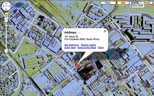
This looks like a heavily posterized image to me, but I doubt that was the case. There must have been some type of interference when the image was captured?

Forum discussion at Google Maps Help.


Popular Categories

The Pulse of the search community

Search Video Recaps

 
Video Details More Videos Subscribe to Videos

Most Recent Articles

Search Forum Recap

Daily Search Forum Recap: December 8, 2025

Dec 8, 2025 - 10:00 am
Google Search Engine Optimization

Google Search Console Insights Adds Social Channels

Dec 8, 2025 - 8:26 am
Google

Google AI Mode Tests Search Live (Voice) With Citation Cards

Dec 8, 2025 - 7:51 am
Google Updates

Google Search Ranking Volatility Heated Over This Past Weekend

Dec 8, 2025 - 7:41 am
SEO Copywriting

Business Insider To Use AI To Publish Quick News Stories

Dec 8, 2025 - 7:31 am
Google Ads

Google Tests Image Animation For Search Ads

Dec 8, 2025 - 7:21 am
 
Previous Story: Bing UK Out of Beta, But Too Soon?